
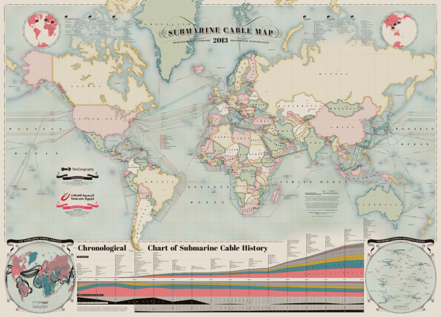
A map of the world and the cables that keep Our world connected(Internet)
TeleGeography released a 2013 version of its Submarine Cable Map on
Thursday showing the 232 cables that ferry telecommunications under water between countries. The mapmakers note the rendering serves as a rough estimator for overall demand for connectivity between places, and that cables to a location mean bandwidth there is generally faster and cheaper than places that must communicate via satellite.
In addition to mapping the locations of the cables, the map shows a chart detailing the names and connectivity of all the cables installed between 1992 and 2012. For instance, the Challenger-Bermuda 1, built by Alcatel-Lucent in 2008, connects the US to Bermuda and had an initial capacity of 20 Gigabits per second, scalable to 320 Gigabits per second. The Unity/EAC-Pacific cable, lit in 2010 and funded in part by Google, connects the US and Japan (and cost around $300 million to build, according to Wired).
In addition to the two larger charts, the map also includes insets that show network latency between countries over their undersea cables. Worst connections: Japan to the UK, the US to South Africa, Brazil to almost everywhere. A second inset shows rough estimations of how heavy transmissions are between countries with the thickness of lines: transatlantic communications are unsurprisingly heavy, but India to Africa and Alaska to Australia are also pretty chatty.
0 comments:
Post a Comment